Search
Or hit enter to search
By Muhammad Abdur Rahaman, Director, Center for People and Environ, Dhaka, Bangladesh
Bangladesh, which ranks among the most populous nations in the world, has experienced rapid population growth over the past century, though it has recently moderated somewhat (UNFPA, 2015). The country is going to witness a rapid spread of urbanisation over the next decade. According to an estimate, by 2050, nearly every other man, woman, and child will live in an urban area (World Bank 2020). Along with the population, the urban climate is also rapidly changing in Bangladesh.
Urbanisation in Bangladesh also led to environmental degradation, including air and water pollution, deforestation, and loss of green spaces. An increasing frequency of extreme weather events is one of the most concerning effects of climate change on urban systems. Urban life is at risk due to an increase in the frequency and severity of heat waves (Revi et al., 2014). Heatwaves can cause an increase in heat stress and mortality, especially in susceptible groups, including the elderly and people with underlying medical issues (Forster et al., 2013). Furthermore, the urban heat island effect is intensified by climate change, leading to higher temperatures in urban areas compared to their rural surroundings, which negatively affects public health (Ahmed et al., 2020).
Nature-based solutions (NbS) for cooling cities in Bangladesh involve using natural systems to mitigate the urban heat island effect and improve urban livability. These solutions include increasing green spaces, such as parks and urban forests, and blue spaces like wetlands and water bodies. Implementing these solutions can significantly reduce temperatures, improve air quality, and enhance the overall well-being of city residents. The study was conducted to find the correlation between the existence of two prominent NbS (vegetation coverage and waterbodies) and the heat island effect, as well as NbS as heat adaptation measures in Bagerhat and Satkhira Municipalities of Bangladesh.
Both municipalities have a diverse landscape with various land cover and land use, including vegetation coverage and waterbodies. In Satkhira municipality, vegetation coverage has approximately 1412.29 hectares, comprising lush greenery and indigenous flora, highlighting the region’s ecological richness. Open spaces, totalling 33.59 hectares, provide recreational areas and potential sites for future development within the urban landscape. Agricultural land spans 1297.70 hectares, emphasising the area’s reliance on farming for sustenance and economic activity. Water bodies covering 240.73 hectares sustain local ecosystems and livelihoods, while lowlands, spanning 16.73 hectares, contribute to the region’s hydrological dynamics (Map 1).
The land use and land cover of Bagerhat Municipality are delineated into various categories. The largest portion of land, encompassing 433.66 hectares, is designated as vegetation, indicating areas primarily covered by natural flora and vegetation. Open space contributes 7.44 hectares, indicating areas with minimal development. Agricultural land covers 53.98 hectares, reflecting areas utilised for farming activities such as the cultivation of crops and livestock. Water bodies, covering 16.27 hectares, include canals, ponds, rivers, and other bodies of water within the municipality. In this municipality, the waterbodies are comparatively lower than those in the Satkhira Municipality; however, two rivers flow beside the municipality (Map 2).
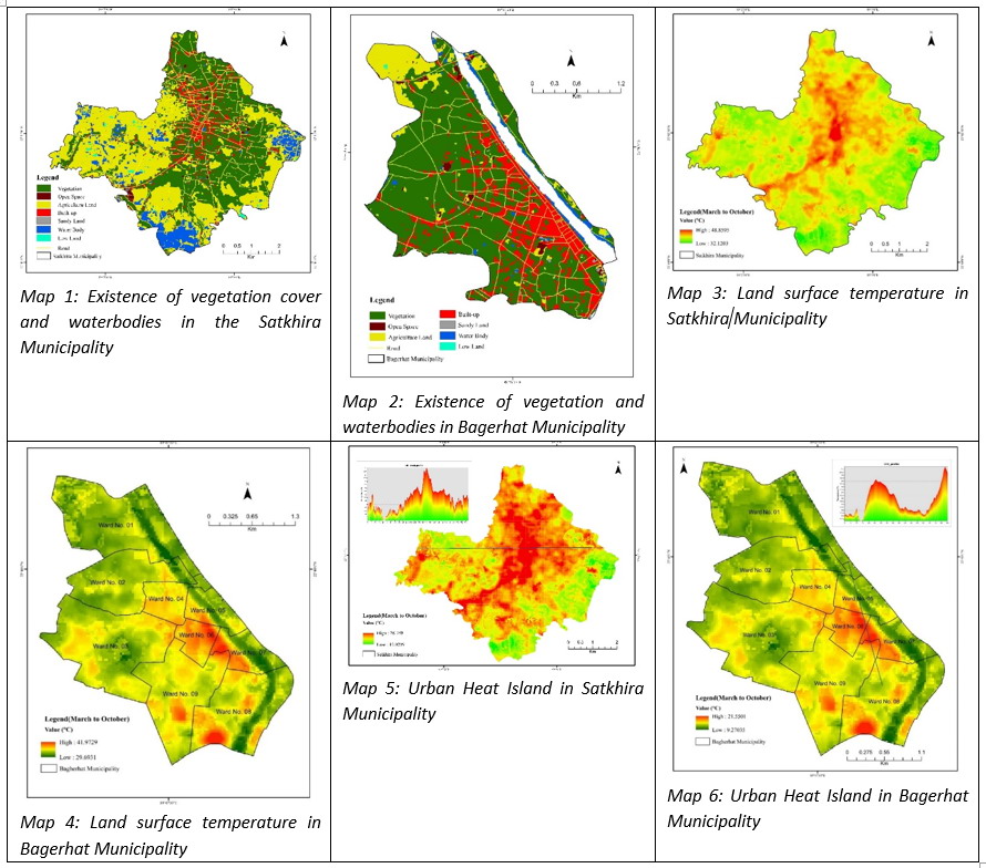
The Land Surface Temperature (LST) of Satkhira Municipality varies from 48°C to 32°C, and in Bagerhat, it varies from 41°C to 29°C. The average temperature of Satkhira Municipality is 38.90 °C, and in Bagerhat Municipality it is 34.71 °C. Wards no.9,8,7,4 have experienced the highest temperature rather to other wards (Maps 3 and 4).
The stack profile represents the temperature variation between urban, suburban, and rural areas. The Urban areas of Satkhira and Bagerhat Municipalities have a higher temperature than the other areas. The urban maximum intensity is 26.76 (°C) and the minimum intensity is 10.02 (°C). The ward no. 9,8, and part of 7 have the highest urban heat island formation in Satkhira Municipality (Map 5).
In Bagerhat Municipality, the urban maximum intensity is 21.55 (°C) and the minimum intensity is 9.27 (°C). The ward no. 8,7,6, and 5 have the highest urban heat island formation (Map 6).
The study revealed that due to the existence of higher vegetation cover and waterbodies in the Bagerhat municipality, the land surface temperature and heat island are comparatively lower than the Satkhira municipality. It is an important part of the heat-adaptive urban system strategy; there needs to enhance green coverage and waterbodies as NbS in urban areas of Bangladesh.
Disclaimer: The views expressed in this piece are those of the author/s and do not necessarily reflect the views or policies of AIDMI.
