Search
Or hit enter to search
By Dr. U.C. Mohanty, Distinguished Professor, Siksha ‘O’ Anusandhan (Deemed to be University), Bhubaneswar; Dr. R. Krishnan, Director IITM; Dr. V.S. Prasad, Director, NCMRWF; and Dr. D.R. Pattanaik, Head NWP Division, IMD, India
Evolution of Numerical Weather Prediction (NWP)
The first successful numerical weather prediction (NWP) was made in 1950 by Jule Charney and John von Neumann, using simplified atmospheric models on a computer at Princeton University, USA. In India, pioneering work in NWP traces back to 1958, with a study led by Prof. P. K. Das that predicted Bay of Bengal monsoon depressions using a non-divergent barotropic model, published in the Indian Journal of Meteorology and Geophysics (Mausam). Later, very important findings published by P. K. Das (1964) on Baroclinic properties of waves behind a large circulation mountain got the 3rd Mausam Award. With this landmark effort, the early and mid-1970s witnessed significant developments in Objective Analysis of meteorological observations, which is a crucial component of numerical weather prediction (NWP). The severe tropical cyclones that struck the Bangladesh coast in 1970, resulting in the loss of over 300,000 human lives caused by a huge storm surge, led to efforts in India for the development of storm surge prediction models. The lead in this direction was taken by Das (1972).
Subsequently, an NWP group was formed at IMD and installed its first computer, an IBM 360/44, in 1973 at its headquarters in New Delhi and was maintained up to 1989 under the leadership of Prof. Das. This system facilitated objective analysis of observation data to provide initial conditions to a barotropic model that was operational in IMD to provide a one- to two-day forecast of the 500 hPa geopotential field and movement of atmospheric vertices such as monsoon depressions and western disturbances.
A new era in NWP began with the establishment of the National Centre for Medium-Range Weather Forecasting (NCMRWF) in 1988, equipped with the Cray-XMP/14 supercomputers. With the installation of a supercomputer, the NCMRWF significantly boosted NWP research and facilitated the development of a full-fledged NWP system to initiate work with global assimilation and prediction systems to provide medium-range forecasts for agrometeorological advisories in the country. The medium-range weather forecasting system was established in June 1994 after extensive experimentation, evaluation and adaptation through dedicated R&D efforts by NCMWF under the guidance of Prof. U. C. Mohanty, Head of the Research Division of the NCMRWF (on deputation from IIT Delhi). Subsequently, the NCMRWF global model provided lateral boundary conditions to the IMD multilevel regional model for short-range (1-3 days) prediction on an operational basis, marking a milestone in operational NWP in India. Subsequently, immense improvements were made in the NCMRWF through advanced data assimilation, sophisticated modelling systems and an ensemble prediction approach.
Advancements in Forecasting Systems
Over the decades, IMD and NCMRWF have made significant progress in improving short- and medium-range NWP systems and providing agrometeorological advisories to 127 agrometeorological zones across the country. These advancements are closely tied to the evolution of high-performance computing, from early machines capable of millions of operations (10⁶ FLOPS) to today’s supercomputers performing at petaflop (10¹⁵ FLOPS) levels.
IMD’s operational forecasts have continuously strived to address severe weather events such as tropical cyclones, storm surges, heavy rainfall, severe thunderstorms, heatwaves, cold waves, and western disturbances over the entire country. In the course of time, coupled Atmosphere-ocean-land models with probable strike potential of tropical cyclones were developed and operationalised with impact-based warning systems to reduce the human casualties. In this regard, it is heartening to illustrate that the two severe cyclones in the recent days such as extremely severe cyclonic storm BIPARJOY (June 2023, in Arabian Sea) crossed Gujarat coast and severe cyclonic storm DANA (Oct 2024, in Bay of Bengal) crossed Odisha coast have resulted in zero human casualty, a dream of coastal dweller of both the basins.
Currently, IMD provides seamless weather and climate services across various time scales ranging from a few hours to a season using mathematical models as given below:
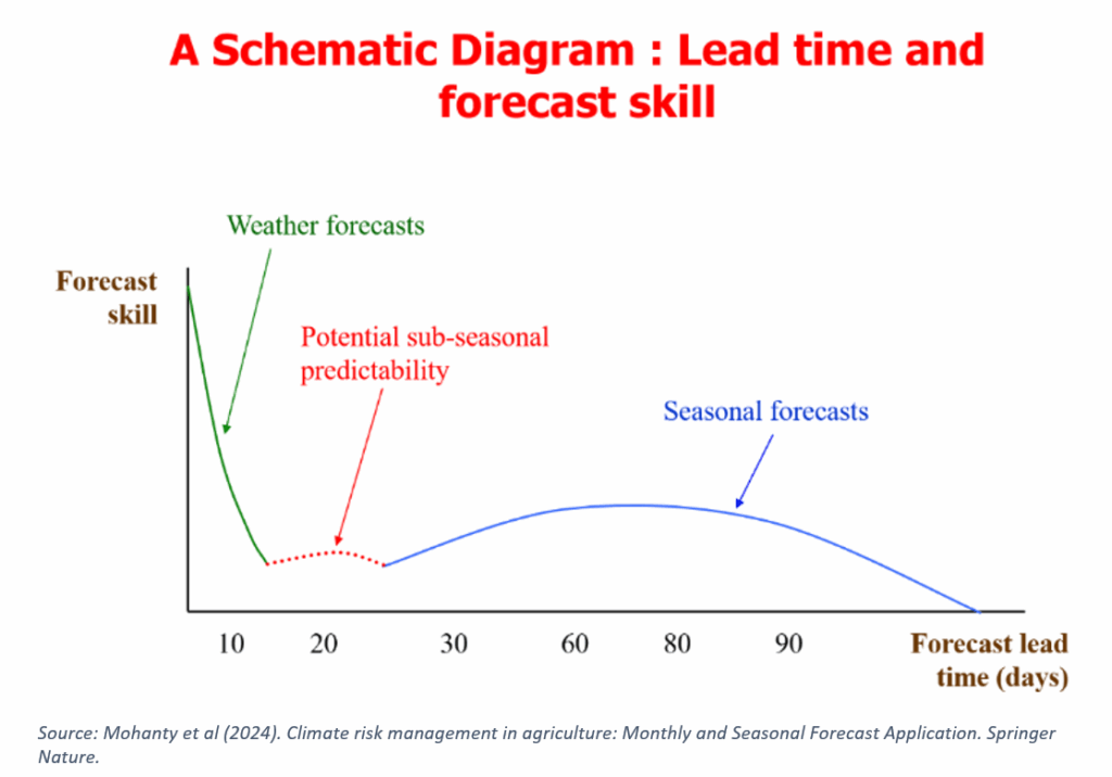
Each of the above forecast have different accuracy depending on the length of the forecast as given in the schematic diagram above. In addition, IMD also delivers agrometeorological advisories and city-specific forecasts for over 150 cities, including inputs for heatwaves, rainfall, and air quality. It is heartening to note that all these forecasts are objective in nature, using numerical models and high-performance computing systems of the MOES.
Contributions to Seasonal and Extended-Range Forecasts
Among the above forecasts, Seasonal and extended-range forecasts are spearheaded by the Indian Institute of Tropical Meteorology (IITM), Pune, under the Ministry of Earth Sciences (MoES), Govt of India. To enhance the accuracy of Indian summer monsoon rainfall forecasts, the Ministry of Earth Sciences (MoES), Government of India, launched the Monsoon Mission in 2012. Under this initiative, the Indian Institute of Tropical Meteorology (IITM), Pune, developed and implemented a state-of-the-art dynamical prediction system based on an atmosphere-ocean-land coupled model for:
(a) Seasonal forecasting of Indian summer monsoon rainfall, and
(b) Extended-range sub-seasonal prediction of monsoon active and break spells.
IMD’s progress in numerical modelling has been bolstered by academic partnerships with leading academic institutions like IIT Delhi and IISc Bangalore and international collaborations primarily with the USA and UK. g
References:
Disclaimer: The views expressed in this piece are those of the author/s and do not necessarily reflect the views or policies of AIDMI.
